Summary "Kyarr is likely to move further northwestwards during next 36 hours and then turn southwestward."
KARACHI (Dunya News) – As the intensity of Very Severe Cyclonic Storm (VSCS) "Kyarr", developed in the east central Arabian Sea, grew on Tuesday, the seawater has started entering into more homes located in the coastal belt areas of Karachi.
Hundreds of people, who were evacuated yesterday, still could not return to their homes and are facing immense difficulties in carrying out their daily life activities, according to latest updates available with the media.
The affected neighbourhoods mainly include Rehri Goth, one of the neighborhoods of Liaquatabad Town, and Lath Basti in Rehri Bin Qasim Town and Chashma Goth.
According to spokesperson of National Disaster Management Authority, in case of any emergency NDMA has established 300 camps in Malir.
Authorities have warned swimmers to refrain from going to beaches in Karachi, Badin and Thatha, and banned boating and fishermen from venturing in the open sea till Nov. 5.
Several villages have been inundated in seawater; however no loss of human life and property damage has been reported so far. Importantly, hundreds of boats are still stuck in the sea and have not returned to the coasts.
Amid panic and fear as sea level rises in the coastal areas of Thatha, people have been forced to leave their homes in more than 20 villages of Shah Bandar area.
According to the Pakistan Meteorological Department’s (PMD) latest advisory, the Super Cyclonic Storm over Eastcentral Arabian Sea has tracked northwestward during last 12 hours and now lay centered near Lat 18.6°N and Long 64.2°E with maximum sustained surface winds of 230-240 kmph gusting 265 kmph, at about 750 km southwest of Karachi and 1080 km northeast of Salalah (Oman).
It stated: “Kyarr is likely to move further northwestwards during next 36 hours and then turn southwestward.”
“There is no direct threat to any coastal area of Pakistan; however, due to exceptionally strong winds around the system’s centre and roughness in sea, low-lying islands may suffer by water intrusion due to high tides.”
The PMD further expected scattered DS/TS-rain in lower Sindh and along Makran Coast during Wednesday-Friday, and advised fishermen to not venture in open sea till 31 Oct.
Tropical Cyclone Warning Center of PMD is regularly monitoring the intensity and track of this Tropical Cyclone. The concerned authorities are requested to keep them abreast of the system updates through PMD website.
Earlier, volunteers of the Fisherman Co-operative Society and employees launched a rescue operation in the affected areas and evacuated more than 100 families to nearby buildings of colleges and schools.
The employees asked the maritime security to provided plastic boats for conducting rescue operation in the affected area.
Kyarr formed early on Oct. 25 from a low-pressure area designated as System 97A in the northern Indian Ocean. It consolidated, and intensified quickly and became a tropical storm just off the southwest India coast.
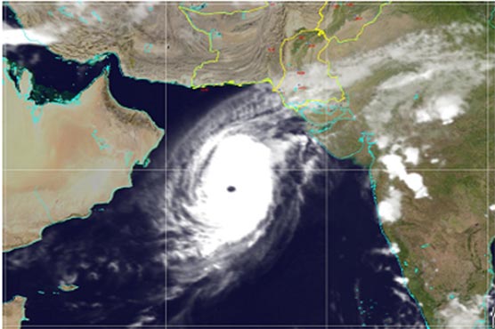
On Oct. 25 at 5:10 a.m. EDT (0910 UTC), the Moderate Imaging Spectroradiometer or MODIS instrument that flies aboard NASA’s Aqua satellite provided a visible image of Kyarr. The image showed that there is a large band of powerful thunderstorms circling Kyarr’s low-level center of circulation. In addition, infrared satellite imagery showed that Kyarr has a solid core of strong convection – that is, rising air which forms the thunderstorms that make up a tropical cyclone, wrap around the low-level circulation center. Microwave satellite imagery revealed the storm had developed an eye, a sign of strengthening.
The shape of the storm was a clue to forecasters that a storm was either strengthening or weakening. If a storm takes on a more rounded shape it implies that it would get more organised and strengthening. Conversely, if it becomes less rounded or elongated, it is a sign the storm is weakening.
At 11 a.m. EDT (1500 UTC) on Oct. 25, the Joint Typhoon Warning Center or JTWC noted Tropical Cyclone Kyarr was located near latitude 16.3 degrees north and longitude 71.9 degrees east, about 579 nautical miles south-southeast of Karachi, Pakistan. Maximum sustained winds were 55 knots (63 mph/102 kph).
At that time, Kyarr was drifting generally northward while located between two subtropical ridges (elongated areas of high pressure) located to the northwest and northeast of the tropical storm. As those ridges strengthen and build, Kyarr was forecasted to turn to the northwest and rapidly intensify.
The JTWC expected the storm to get intensify after three days, but predicted it to get weaken on approach to the Oman coastline.