Summary The PMD further advised fishermen to remain alert and not to venture in deep sea from Monday.
KARACHI (Dunya News) – At least 185 houses have been affected as water entered the coastal belt of Karachi, including Rehri Goth, one of the neighborhoods of Liaquatabad Town, and Lath Basti in Rehri Bin Qasim Town as a Very Severe Cyclonic Storm (VSCS) "Kyarr" developed in the east central Arabian Sea and moves west-northwestward at about 745km southwest of Karachi and 1,180km east of Salalah (Oman).
About 500 people have been evacuated from the affected coastal belt. Pakistan Peoples Party (PPP) MNA Agha Rafi Ullah told the media that temporary camps were being set up for the affectees to stay. Edhi officials said that the situation in Ibrahim Hyderi area was out of danger.
The Pakistan Meteorological Department (PMD) today issued an updated advisory about the VSCS "Kyarr" in the Central Arabian Sea.
“The Super Cyclonic Storm over Eastcentral Arabian Sea has moved further west-northwestward during last 12 hours and now lay centered at 0800 PST of 28th October, 2019 near Lat 18.3°N and Long 65.2°E with maximum sustained surface winds of 230-240 kmph gusting 265 kmph,” the PMD mentioned.
It stated: “The Super Storm Kyarr is likely to move further northwestwards towards Oman coast during next few days.”
The PMD, in its advisory, stated that "none of the Pakistan coastal area is under direct threat from this system".
“However, under its influence scattered DS/TS-rain is expected in lower Sindh and along Makran Coast during Wednesday-Friday.” The PMD further advised fishermen to remain alert and not to venture in deep sea from today.
The Tropical Cyclone Warning Center (TCWC) of the PMD is regularly monitoring the intensity and track of this tropical cyclone. The concerned authorities are requested to keep them abreast of the system updates through PMD website.
.jpg)
.jpg)
.jpg)
.jpg)
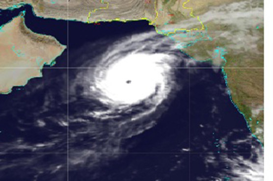
Kyarr formed early on Oct. 25 from a low-pressure area designated as System 97A in the northern Indian Ocean. It consolidated, and intensified quickly and became a tropical storm just off the southwest India coast.
On Oct. 25 at 5:10 a.m. EDT (0910 UTC), the Moderate Imaging Spectroradiometer or MODIS instrument that flies aboard NASA’s Aqua satellite provided a visible image of Kyarr. The image showed that there is a large band of powerful thunderstorms circling Kyarr’s low-level center of circulation. In addition, infrared satellite imagery showed that Kyarr has a solid core of strong convection – that is, rising air which forms the thunderstorms that make up a tropical cyclone, wrap around the low-level circulation center. Microwave satellite imagery revealed the storm had developed an eye, a sign of strengthening.
The shape of the storm was a clue to forecasters that a storm was either strengthening or weakening. If a storm takes on a more rounded shape it implies that it would get more organised and strengthening. Conversely, if it becomes less rounded or elongated, it is a sign the storm is weakening.
At 11 a.m. EDT (1500 UTC) on Oct. 25, the Joint Typhoon Warning Center or JTWC noted Tropical Cyclone Kyarr was located near latitude 16.3 degrees north and longitude 71.9 degrees east, about 579 nautical miles south-southeast of Karachi, Pakistan. Maximum sustained winds were 55 knots (63 mph/102 kph).
At that time, Kyarr was drifting generally northward while located between two subtropical ridges (elongated areas of high pressure) located to the northwest and northeast of the tropical storm. As those ridges strengthen and build, Kyarr was forecasted to turn to the northwest and rapidly intensify.
The JTWC expected the storm to get intensify after three days, but predicted it to get weaken on approach to the Oman coastline.